Best Map Toys for Kids to Learn Geography
Exploring the world is easier when learning comes with hands-on fun. The map-themed toys below help kids discover countries, capitals, landmarks, and oceans while building memory, spatial skills, and critical thinking. Each pick offers interactive or tactile experiences suited for different ages and learning styles. The list focuses on screen-free options and engaging electronic maps that encourage exploration at home, in classrooms, or during travel.
| Product | Brand | Key Focus |
|---|---|---|
| United States Puzzles for Kids Ages 4-6 | Momo & Nashi | Geography, States & Capitals |
| BEST LEARNING i-Poster My World | BEST LEARNING | Interactive World Map |
| Qiaojoy V2 Interactive United States Map | Qiaojoy | Bilingual Map, Audio |
| BEST LEARNING i-Poster My USA | BEST LEARNING | Interactive USA Map |
| Montessori Mama USA Map Wooden Puzzle | Montessori Mama | Hands-on US Geography |
United States Puzzles for Kids Ages 4-6

Build critical thinking and spatial reasoning with a large USA map puzzle designed for ages 4-6. The 70-piece floor puzzle helps children recognize all 50 states and capitals through hands-on play, reinforcing memory, color recognition, and visual-spatial awareness. It supports Montessori-inspired learning, early cognitive growth, and screen-free engagement. The vibrant design makes geography approachable for homeschooling, classrooms, or family learning activities. The puzzle also serves as a gift-friendly option for holidays and birthdays.
Key features include: large pieces for developing motor skills, state-symbol associations, and a practical framework for guided geography lessons. This puzzle combines educational value with durable, kid-friendly construction to encourage repeated exploration. It remains a solid choice for parents seeking a tangible, immersive geography experience.
BEST LEARNING i-Poster My World
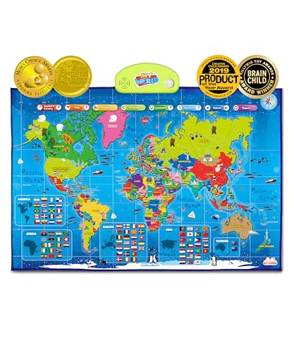
Interactive world map for kids ages 5-12, offering touch-activated learning with over 500 voice-guided questions. The device-friendly design introduces countries, flags, oceans, continents, landmarks, and global facts, promoting STEM curiosity and global awareness. It has earned awards that reflect its educational value and durability, making it a dependable classroom or home learning tool.
Key aspects include: engaging audio prompts, award-winning status, and broad geographic coverage. The i-Poster supports wall or floor use, enabling varied study formats and collaborative quizzing. Its interactive format helps kids retain geography knowledge through repeat interaction and curiosity-driven exploration.
Qiaojoy V2 Interactive United States Map

The bilingual US map offers an engaging, interactive learning experience for kids aged 3-12. It features a customizable start-up sound, recording capabilities, and a stylus for interactive play. The map emphasizes an interdisciplinary approach with 10 interactive features and thousands of geographic facts, alongside state-capital connections. This makes it a robust tool for language learners and homeschooled students seeking an electronic map experience.
Highlights include: bilingual functionality (English and Spanish), a DIY wand, and a broad factual catalog about the United States. The design encourages storytelling and personalized learning, letting children create their own educational world through interactive play.
BEST LEARNING i-Poster My USA

Interactive United States map designed for ages 5-12, enabling children to tap states and hear their names, capitals, and more than 500 spoken facts. The poster format supports wall or floor use, aiding flexible study setups in classrooms or homes. Award-winning and trusted by parents, the i-Poster combines tactile interaction with memory-building prompts for geography lessons.
Key benefits include: rich audio content, versatile placement options, and a durable, educational design. This product is well-suited for group activities and solo practice, offering a dynamic way to reinforce US geography knowledge.
Montessori Mama USA Map Wooden Puzzle

Montessori Mama offers a wooden puzzle that teaches US geography through hands-on exploration. Designed for ages 4-8, the puzzle includes all 50 states, capitals, landmarks, and state symbols. Its durable wooden construction supports repeated use in homes or classrooms, while the detailed pieces help children develop fine motor skills and geographic knowledge in a tactile setting.
Considerations include: natural materials for durability, a comprehensive state-and-capital focus, and compatibility with Montessori-style learning. The puzzle supports collaborative learning and independent problem-solving, providing a reliable physical tool for geography lessons and exploration.]
Buying Guide: Map Toys For Kids
- Age range and learning style: Choose a product that matches your child’s age, attention span, and preference for interactive versus tactile play. Younger kids may benefit from large-piece floor puzzles, while older children may enjoy audio-enabled or bilingual maps.
- Content scope: Decide whether you want national-level focus (United States states and capitals) or global learning (world maps, oceans, landmarks). Some products emphasize language learning through bilingual features, which can be advantageous for households developing bilingual skills.
- Interactivity level: For screen-free learning, select puzzles or wall-floor posters that require problem-solving and memory. If you prefer engaging tech elements, consider interactive maps with voice guidance and recording options that support storytelling and practice.
- Durability and material: Wooden puzzles tend to be sturdy for long-term use, while cardboard or foam maps are lighter and more affordable. Check piece durability and finish, particularly for younger children who rough-handle objects.
- Placement flexibility: Wall-mounted posters or floor mats offer different learning environments. Consider where you’ll place the map toy (classroom, bedroom, living room) and whether you want a combination of formats in a single product line.
- Educational outcomes: Look for products that emphasize geographic literacy, memory, and spatial reasoning. Features like capitals, landmarks, flags, and cultural facts can enhance a well-rounded geography education.
- Awards and credibility: Award-winning products often reflect tested educational value and durability. Parent and educator reviews can help gauge real-world effectiveness and engagement.
- Budget and space: Large floor puzzles and interactive posters vary in cost and footprint. Ensure the product fits your available space and aligns with your budget while delivering meaningful learning experiences.
- Maintenance: Some interactive maps require batteries or styluses. Plan for replacement parts and consider ease of cleaning and storage after use.
In summary, the best map toys balance tactile play with educational depth. Whether seeking a hands-on wooden puzzle, a multi-sensory talking map, or a bilingual interactive poster, the selections above provide varied approaches to teaching geography while keeping children engaged and curious about the world.